Satellites and Satellite Networks.

Satellites:
A satellite is a man-made object that orbits a planet or other celestial body. They range in size from mere cubesats to massive space telescopes, each serving a specific purpose. In essence, they are like artificial moons, constantly circling
Satellite Networks:
A satellite network is a system of multiple satellites working together to provide communication, navigation, data collection, and other services over a wide area. These networks rely on complex ground stations and sophisticated technology to facilitate information exchange between satellites and users on Earth.
Types of Satellites and Satellite Networks
Satellites are usually classified based on their orbital altitude (distance from the Earth’s surface), which directly affects their coverage and the speed at which they travel around the planet[1].
The following are some of the main types of satellites based on their orbits.
- Low Earth Orbit (LEO);
- Medium Earth Orbit (MEO);
- High Earth Orbit (HEO);
- Geostationary Earth Orbit (GEO);
- Sun-Synchronous Orbit (SSO);
- Geostationary Transfer Orbit (GTO).
The following diagram from[1] abstractly shows the heights/distance of the orbits of different types of satellites. (Note: In fact, this image is not in actual scale)
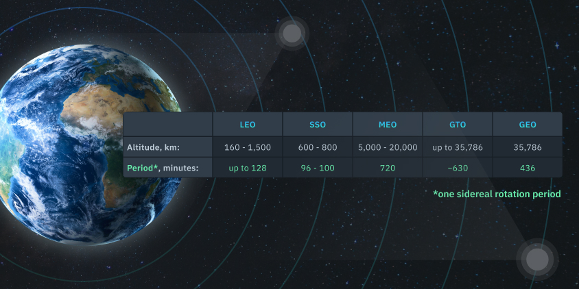
Even though there are so many types of satellite networks, LEO, MEO and GEO satellite networks are the major types of satellite networks that are interesting candidates for routing and other kinds of networking-related research; because, generally, a typical all these three satellite networks were composed of many satellites that will be deployed for a global usage of application in mind. The following presents some of the attributes of these three kind of satellite networks.
-
Altitude:
- LEO: 160 to 2,000 kilometers above Earth.
- MEO: Approximately 2,000 to 35,786 kilometers above Earth.
- GEO: Approximately 35,786 kilometers above the equator.
-
Coverage:
- LEO: Provides a relatively small coverage area per satellite, but low latency due to proximity to Earth. Many satellites are needed for global coverage.
- MEO: Offers larger coverage compared to LEO, and fewer satellites are needed for global coverage. Latency is higher than LEO but lower than GEO.
- GEO: Provides broad coverage over one-third of the Earth’s surface. A few GEO satellites can cover a large area but with higher latency.
-
Latency:
- LEO: Low latency due to the proximity to Earth. This makes LEO satellites suitable for applications where low latency is critical, such as real-time communication.
- MEO: Moderate latency, higher than LEO but lower than GEO. MEO satellites are often used for navigation systems.
- GEO: Higher latency compared to LEO and MEO due to the longer signal travel time. This can impact real-time communication applications.
-
Applications:
- LEO: Ideal for applications requiring low latency, such as broadband internet, Earth observation, and remote sensing. SpaceX’s Starlink is an example.
- MEO: Commonly used for navigation and positioning systems like GPS (Global Positioning System).
- GEO: Suitable for applications where continuous coverage of a specific region is required, such as weather monitoring, television broadcasting, and communication services.
The choice between LEO, MEO, and GEO satellite networks depends on the specific requirements of the applications. LEO provides low latency but requires a larger number of satellites, MEO offers a balance between coverage and latency, and GEO provides continuous coverage over a fixed area with higher latency. Each orbit has its advantages and trade-offs based on the intended use case.
Popular LEO networks
The following are some of the most popular and well-known examples of LEO satellite networks:
-
Starlink:
- Developed by SpaceX, aiming to provide global broadband internet access.
- Currently has over 2500 satellites in orbit, with plans for tens of thousands more.
- Offers high speeds and low latency, making it suitable for gaming, streaming, and other demanding applications.
-
OneWeb:
- Backed by a consortium of companies, focused on providing global internet and communication services.
- Has launched over 400 satellites so far, with plans for a total of 648.
- Targets rural and remote areas that lack reliable terrestrial internet access.
-
Kuiper:
-
- Plans to launch 3,236 satellites, with the first prototype satellites launched in 2022.
- Aims to provide high-speed, low-latency internet to homes, businesses, and government organizations.
-
-
Iridium:
- A long-standing LEO satellite constellation providing voice and data communication services worldwide.
- Comprises 66 satellites, offering global coverage even in remote regions.
- Used for satellite phones, maritime communication, aviation tracking, and other applications.
-
Globalstar:
- Another established LEO constellation offering satellite phone and low-speed data services.
- Has 24 satellites in orbit, primarily serving rural and remote areas.
- Used for voice calls, text messaging, asset tracking, and emergency communication.
-
Telesat Lightspeed:
- A Canadian-based LEO network under development, aiming to provide global broadband internet and enterprise services.
- Plans to launch 298 satellites, with the first launch scheduled for 2023.
- Targets high-speed connectivity for businesses, governments, and institutions.
-
O3b mPOWER:
- A second-generation LEO constellation from SES, providing high-throughput satellite internet and connectivity services.
- Will consist of 11 satellites, offering fiber-like speeds and low latency for enterprises and governments.
- Expected to launch in 2023.
These are just a few examples of the many LEO satellite networks currently in operation or under development. The field is rapidly evolving, with new players and technologies emerging, promising to expand the reach and capabilities of satellite-based communication and internet access worldwide.
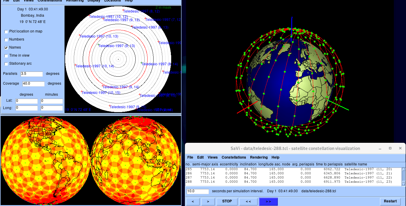
An Example Visualization of a Typical LEO Network (Teledesic-288).
The following gif animation shows a few seconds of the movements and coverage of the LEO Teledesic-288 satellite network. The fish-eye view of the sky in Bombay, India is shown at the left-top window. The coverage on the two sides of the globe is visualized in the Left-bottom window. The movements of the 288 satellites are shown in the Right-Bottom Window. The Right Bottom window displays the parameters of all the satellites.
Popular MEO networks
While MEO networks are primarily used for navigation systems like GPS, there are a few notable satellite constellations operating in Medium Earth Orbit that offer valuable services besides location services:
Galileo:
-
-
- Developed by the European Union, this GNSS (Global Navigation Satellite System) competes with GPS and offers comparable positioning accuracy and global coverage. It currently has 28 operational satellites and 6 spares in MEO.
- Offers high-precision positioning for land, sea, and air navigation, alongside scientific applications like atmospheric studies and disaster management.
-
GLONASS:
-
-
- The Russian Federation’s GNSS system, operational since the 1990s. Currently has 24 operational satellites and 7 spares in MEO.
- Provides global navigation and positioning services, primarily used within Russia and neighboring countries.
-
Beidou:
-
-
- China’s GNSS system, rapidly expanding with plans for global coverage. Currently has 35 operational satellites and 13 spares in MEO.
- Offers navigation and positioning services for land, sea, air, and space applications. Some countries integrate Beidou with their national navigation systems.
-
BeiDou Navigation Satellite System (BDS)-3:
-
-
- The third-generation constellation of Beidou, aims for further improved accuracy and global coverage. Expected to complete deployment by 2035 with 33 MEO satellites and 3 GEO satellites.
-
Galileo-2:
-
-
- The future evolution of Galileo, is planned to introduce new features and enhanced signal strength. Scheduled for deployment in phases through the 2030s, with some MEO and GEO satellites planned.
-
While GNSS systems are the most prominent MEO networks, several smaller constellations in MEO provide specialized services:
-
-
- Orbcomm: Low-bandwidth data communications for asset tracking, fleet management, and remote monitoring.
- EchoStar Mobile Service: Mobile voice and data services for users in remote areas where terrestrial coverage is limited.
- Iridium Next: Provides additional low-bandwidth data services alongside its global mobile voice network.
-
As technology advances and MEO becomes a more viable platform for various applications, we can expect to see more diversified MEO networks emerge in the future, potentially playing a larger role beyond just navigation services.
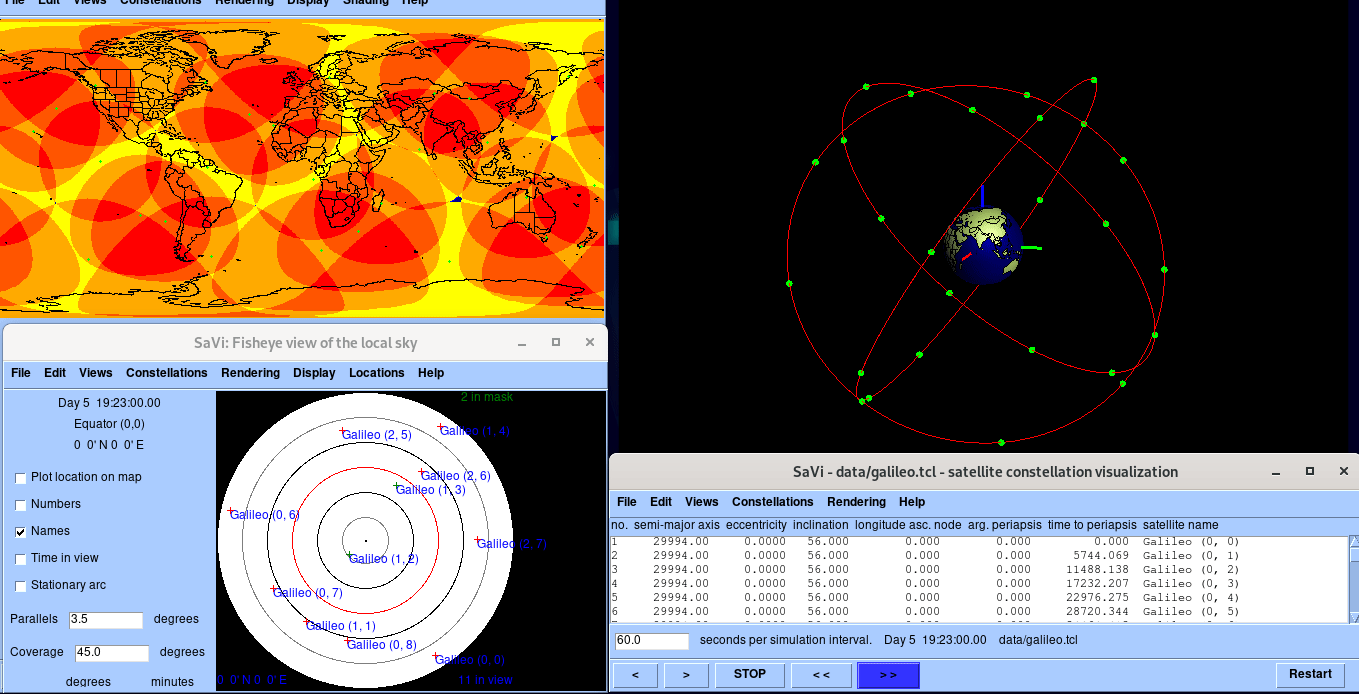
An Example Visualization of a Typical MEO Network (Galileo).
The following gif animation shows a few seconds of the movements and coverage of the MEO Galileo satellite network. The fish-eye view of the sky in Bombay, India is shown at the left-top window. The coverage is visualized in the conventional map at the Left-bottom window. The movements of the satellites were shown in the Right-Bottom Window. The Right Bottom window displays the parameters of all the satellites.
Popular GEO networks
When it comes to GEO networks, they tend to be well-established and dominant in specific areas due to their unique characteristics. The following are some of the most popular GEO networks:
Broadcasting:
-
-
- SES: A leading global provider of satellite broadcasting services, operating over 70 GEO satellites. They cover diverse TV channels, radio programs, and other media content distribution across all continents.
- Eutelsat: Another major player in satellite broadcasting, offering regionalized packages for Europe, Africa, the Middle East, and Asia. Their portfolio includes news, sports, entertainment, and government channels.
- Intelsat: A long-standing operator with a legacy in broadcasting and international communications. They provide satellite solutions for TV channels, government networks, and maritime communication.
-
Mobile Communication:
-
-
- Inmarsat: A well-known provider of mobile satellite services for maritime, aeronautical, and land mobile users. They offer voice, data, and broadband connectivity in remote and offshore locations.
- Iridium Next: The second-generation constellation of Iridium, offering global mobile voice and data services even in areas with no terrestrial coverage. Their network is known for its reliability and durability.
- Thuraya: A regional player focusing on mobile communication services in the Middle East, Africa, and Central Asia. They offer satellite phones, internet access, and other communication solutions for remote areas.
-
Other applications:
-
-
- EchoStar: An American provider of satellite services for broadcasting, internet access, and government communications. They operate a large fleet of GEO satellites with diverse applications.
- Hispasat: A Spanish satellite operator offering broadcasting, broadband internet, and government communication services across Europe and Latin America. They specialize in high-power broadcast solutions.
- Telesat: A Canadian company providing satellite services for broadcasting, telecommunications, and government applications. They operate a fleet of GEO satellites, primarily focusing on North America.
-
These are just a few examples, and the popularity of GEO networks can vary depending on the region and specific application. While LEO networks are gaining traction in some areas, GEO networks remain vital for broadcasting, mobile communication in remote areas, and other specialized applications where their wide coverage and stability are crucial.
It’s also important to note that hybrid networks combining GEO and LEO technologies are emerging, aiming to leverage the strengths of both types of satellites for more diverse and efficient communication solutions.
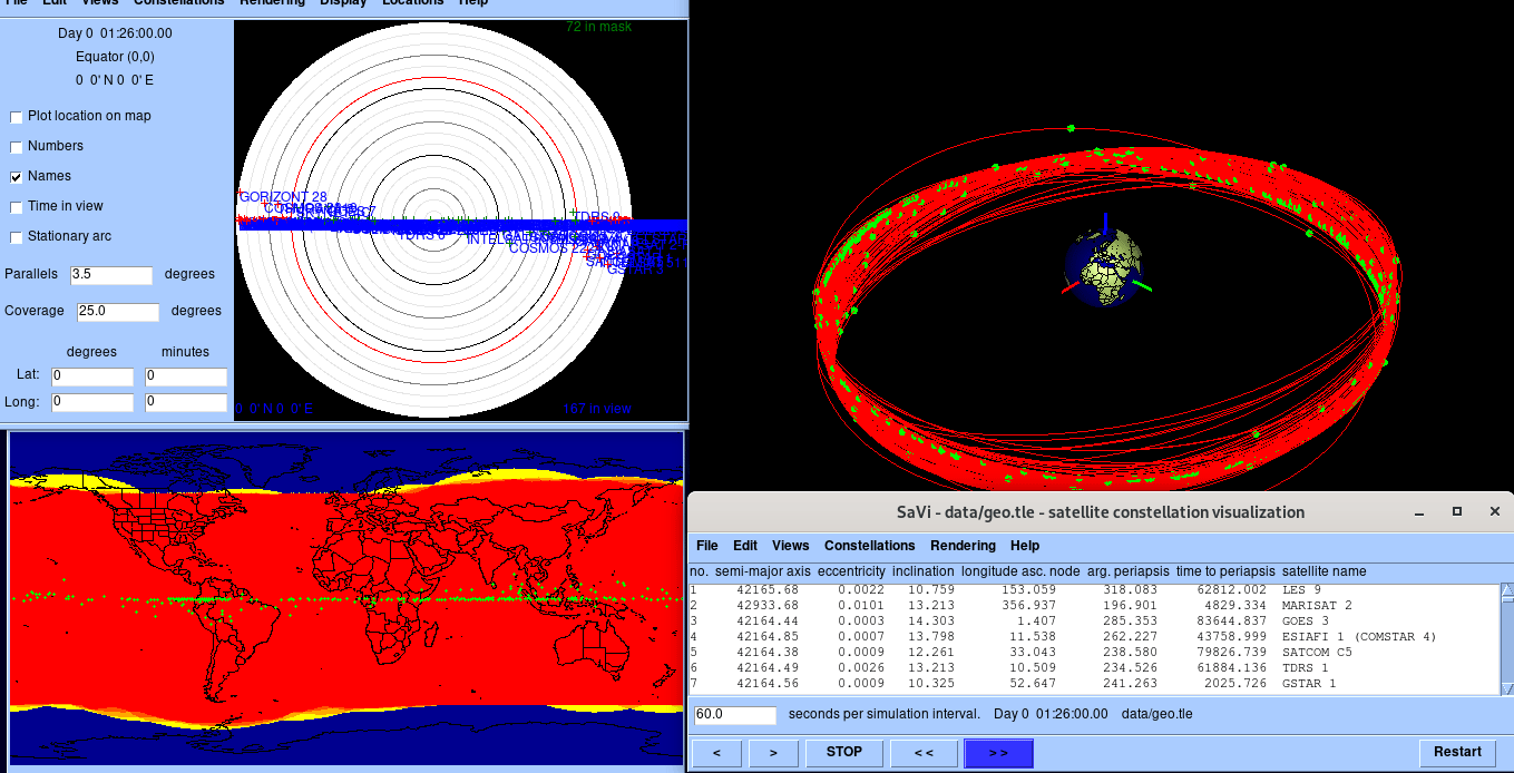
The GEO satellites
The following gif animation shows a few seconds of the movements and coverage of the GEO satellites (network). The fish-eye view of the sky in Bombay, India is shown at the left-top window. The coverage is visualized in the conventional map at the Left-bottom window. The movements of the satellites were shown in the Right-Bottom Window. The Right Bottom window displays the parameters of all the satellites.
HEO (High Earth Orbit) Satellite[2]
-
-
- The High Earth orbit satellite is the only non-circular orbit which differ from the other types.
- HEO satellite operates with an elliptical orbit, with a maximum altitude (apogee) similar to GEO, and a minimum altitude (perigee) similar to the LEO.
- The HEO satellites are used for special applications where coverage of high-latitude locations is required.
-
Even there are a lot of special purpose satellites that are launched with some specific purposes. This article does not discuss them, We may discuss them in one of our future articles.
The Procedure for Creating Above Visualization
The following section explains the installation of dependencies and software tools needed for creating the above visualizations of satellite networks.
Conclusion
This article presents the fundamentals of satellites and satellite networks. This kind of visualization will be very useful to understand the topology, coverage and other aspects of the satellite network while developing research problems related to satellites and satellite networks.
References
 Take Me to Afarion ns-3 iPlayground